© Arbeitsgemeinschaft Biologischer Umweltschutz im Kreis Soest e.V - Natalia Jaworski

© Arbeitsgemeinschaft Biologischer Umweltschutz im Kreis Soest e.V - Natalia Jaworski

© Arbeitsgemeinschaft Biologischer Umweltschutz im Kreis Soest e.V - Naturschätze Südwestfalens entdecken
Datum för turné
4,83km
65
- 72m
4hm
7hm
00:30h

- Kort beskrivning
-
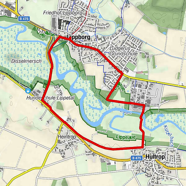
The Lippe floodplain in Lippborg is located in the northwestern part of the District of Soest. You can experience some of the renatured Lippe with its natural dynamics here. River bank reinforcements have been largely removed in this section.
- Svårighet
-
lätt
- Utvärdering
-
- Väg
-
LippborgHeintrop1,6 kmHultrop2,5 kmLippborger Hof4,6 kmCornelius und Cyprianus4,6 kmWillenbrink4,6 kmLippborg4,7 km
- Bästa säsongen
-
janfebmaraprmajjunjulaugsepoktnovdec
- Högsta punkt
- 72 m
- Destination
-
Car park on Ilmerweg in Lippborg
- Höjdprofil
-
 © outdooractive.com


- Författare
-
Turnén Lippeaue - Lippe Floodplain Lippborg around Lippborg används av outdooractive.com förutsatt.
GPS Downloads


Allmän information
Fauna
Fler turer i regionerna
-
Münsterland
61
-
Kreis Soest - Hellweg Börde
115
-
Soest
57