© APT - Valsugana e Lagorai - APT Valsugana

© APT - Valsugana e Lagorai - Cristina Facen

© APT - Valsugana e Lagorai - Cristina Facen

© APT - Valsugana e Lagorai - Cristina Facen

© APT - Valsugana e Lagorai - APT Valsugana

- Kort beskrivning
-
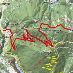
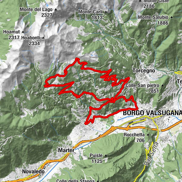
Route of about 30 km of medium difficulty that will take you to the discover the green mountain of Roncegno, among pastures, alpine hut and pretty mountain huts
- Svårighet
-
medium
- Utvärdering
-
- Väg
-
Pizzeria il Picchio0,2 kmRoncegno Terme0,3 kmSanti Pietro e Paolo0,9 kmGionzeri1,8 kmStralleri di Sotto2,0 kmPìnzeri2,4 kmMaso Rincheri2,5 kmPicco3,0 kmRoveri (850 m)4,3 kmScali (730 m)4,5 kmMontibelleri (880 m)5,3 kmRozza6,0 kmFraineri (1.001 m)6,6 kmFodra6,9 kmPozze10,4 kmRistorante alle Pozze10,4 kmSerot12,5 kmRifugio Serot (1.566 m)12,6 kmTrenca13,6 kmAgriturismo Paradiso14,8 kmDesene di Sopra16,4 kmDesene di Sotto17,0 kmMeusi18,8 kmLa Bessa20,4 kmGanarini21,1 kmZurli21,5 kmDosso22,3 kmCaumi (900 m)22,6 kmMoneghetti23,1 kmCanai (830 m)23,1 kmTrozzo23,5 kmRonchi Valsugana23,7 kmMarchi23,8 kmStanghelini24,2 kmBosco (797 m)24,2 kmFrazione Pra25,6 kmVilla Argentina27,2 kmBorgo Valsugana27,4 kmMadonna di Onea27,4 kmSavaro28,0 kmMaso Carota28,4 kmMaso Rigo28,5 kmMaso Vazzena29,2 kmRoncegno Terme30,3 kmPizzeria il Picchio30,6 km
- Bästa säsongen
-
janfebmaraprmajjunjulaugsepoktnovdec
- Högsta punkt
- 1.686 m
- Destination
-
Località Trenca
- Höjdprofil
-
 © outdooractive.com

- Författare
-
Turnén Roadbike - Roncegno - Ronchi (Mountain of Roncegno) används av outdooractive.com förutsatt.
GPS Downloads


Allmän information
Förfriskningsstopp
Lovande
Fler turer i regionerna