

Rundturer Faido
Tillbaka
Välj land
Österrike
Välj alla
Carinthia
Lower Austria
Upper Austria
Salzburg
Steiermark
Tyrol
Vorarlberg
Burgenland
Vienna
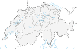
Schweiz
Välj alla
Grisons
Ticino
Wallis
Vaud
Bern
Jura
Bern
Lucerne
Basel-Landschaft
Zürich
Ostschweiz
Fribourg
Geneva
Aargau
Basel-City
Appenzell
Tyskland
Välj alla
Rhineland-Palatinate
North Rhine-Westphalia
Sachsen
Lower Saxony
Mecklenburg-Vorpommern
Baden-Württemberg
Thuringia
Hesse
Bavaria
Saarland
Sachsen-Anhalt
Brandenburg
Schleswig-Holstein
Bremen
Berlin
Hamburg
Italien
Välj alla
Veneto
Provincia di Trento
Lombardy
Aosta Valley
Piedmont
South Tyrol
Friuli – Venezia Giulia
Abruzzo
Toscana
Emilia-Romagna
Marche
Lazio
Molise
Umbria
Calabria
Ligurien
Kampanien
Basilicata
Sardinien
Sicilien
Apulia
Slovenien
Välj alla
Mura Statistical Region
Podravska regija
Koroška regija
Savinja Statistical Region
Zasavska regija
Jugovzhodna Slovenija
Osrednjeslovenska regija
Littoral–Inner Carniola Region
Upper Carniola Statistical Region
Goriška regija
Obalno-kraška regija
Lower Sava Statistical Region
Frankrike
Välj alla
Auvergne-Rhône-Alpes
Provence-Alpes-Côte d'Azur
Occitanien
Hauts-de-France
Pays de la Loire
Korsika
Ile-de-France
Grand Est
Centre-Val de Loire
Nouvelle-Aquitaine
Brittany
Lower Normandy
Bourgogne – Franche-Comté
Nederländerna
Välj alla
North Holland
South Holland
Utrecht
Limburg
Frisia
Groningen
North Brabant
Gelderland
Zeeland
Flevoland
Overijssel
Drenthe
Belgien
Välj alla
Flanders
Vallonien
Brussels
Polen
Välj alla
Lillpolens vojvodskap
Nedre Karpaternas vojvodskap
Nedre Schlesiens vojvodskap
Kujavien-Pommerns vojvodskap
Schlesiens vojvodskap
Podlasiens vojvodskap
Heligt Kors vojvodskap
Pommerns vojvodskap
Ermland-Masuriens vojvodskap
Storpolens vojvodskap
Lublins vojvodskap
Łódź vojvodskap
Opole vojvodskap
Lubusz vojvodskap
Västpommerns vojvodskap
Masoviens vojvodskap
Liechtenstein
Tjeckien
Välj alla
Central Bohemia
Olomouc Region
Moravian-Silesian Region
Zlín Region
South Moravian Region
Pardubice Region
Pardubice Region
Hradec Králové Region
Liberec
Olomouc Region
Karlovy Vary Region
South Bohemian Region
Plzeň Region
okres Hlavní město Praha
Ústí nad Labem Region
Vysočina Region
Slovakien
Välj alla
Region of Bratislava
Region of Trnava
Region of Trenčín
Region of Nitra
Region of Žilina
Region of Banská Bystrica
Region of Prešov
Region of Košice
Spanien
Välj alla
Aragon
Katalonien
Andalusien
Castile and León
Community of Madrid
Asturien
Cantabria
Rioja
Galicia
Valencian Community
Balearerna
Canary Islands
Castile-La Mancha
Extremadura
Region of Murcia
Navarre
Baskien
Kroatien
Välj alla
Istria County
Primorje-Gorski Kotar County
Lika-Senj County
Zadar County
Šibenik-Knin County
Split-Dalmatia County
Dubrovnik-Neretva County
City of Zagreb
Bjelovar-Bilogora County
Slavonia
City of Zagreb
Krapina-Zagorjes
Varaždin County
Međimurjes län
Koprivnica-Križevci County
Virovitica-Podravina County
Osijek-Baranja County
Vukovar-Srijem County
Brod-Posavina County
Sisak-Moslavina County
Karlovac County
Zagrebs län
Bosnien och Hercegovina
Välj alla
Serbiska republiken
Bosnien och Hercegovina
Distriktet Brčko
Luxemburg
Välj alla
Luxemburg
Canton Mersch
Canton Luxembourg
Canton Redange
Germany-Luxembourg condominium
Canton Echternach
Canton Vianden
Canton Grevenmacher
Canton Diekirch
Canton Remich
Canton Wiltz
Canton Clervaux
Canton Esch-sur-Alzette
Canton Capellen
Andorra
Portugal
Välj alla
Braga
Porto
Coimbra
Faro
Viana do Castelo
Aveiro
Santarém
Portalegre
Setúbal
Castelo Branco
Leiria
Beja
Viseu
Évora
Vila Real
Guarda
Bragança
Lisbon
Azorerna
Madeira
Island
Välj alla
Västfjordarna
Northwestern Region
Northeastern Region
Capital Region
Western Region
Southern Peninsula
Eastern Region
Southern Region
Storbritannien
Välj alla
England
Wales
Nordirland
Skottland
Irland
Välj alla
Kerry
County Donegal
County Mayo
Cork
Kilkenny
Carlow
Waterford
Wexford
Meath
County Dublin
Tipperary
Kildare
County Louth
County Monaghan
Roscommon
Westmeath
Longford
Clare
County Galway
Laois
Leitrim
Limerick
County Sligo
Offaly
County Wicklow
Cavan
Grekland
Välj alla
Eastern Macedonia and Thrace
Crete
Western Greece
Attica
Central Greece
Thessaly
Ioanian Islands
Epirus
Western Macedonia
Central Macedonia
Peloponnese
Albanien
Välj alla
Beratprefekturen
Fier prefektur
Korçë prefektur
Vlorë prefektur
Gjirokastër prefektur
Kukës prefektur
Elbasan prefektur
Dibër prefektur
Durrës prefektur
Tiranë prefektur
Shkodër prefektur
Lezhë prefektur
Nordmakedonien
Välj alla
Skopje Region
Vardar Region
Southwestern Region
Polog Region
Pelagonia Region
Northeastern Region
Eastern Region
Southeastern Region
Malta
Välj alla
Northern Region
Southern Region
Central Region
Gozo Region
South Eastern Region
Norge
Välj alla
Finnmark
Jan Mayen
Rogaland
Vestfold
Agder
Vestland
Nordland
Oslo
Østfold
Buskerud fylke
Møre og Romsdal
Telemark
Innlandet
Akershus fylke
Trøndelag
Troms
Svalbard
Montenegro
Välj alla
Danilovgrad Municipality
Ulcinj Municipality
Žabljak Municipality
Mojkovac Municipality
Podgorica Capital City
Berane Municipality
Bar Municipality
Zeta Municipality
Petnjica Municipality
Budva Municipality
Kolašin Municipality
Andrijevica Municipality
Old Royal Capital Cetinje
Tivat Municipality
Plužine Municipality
Herceg Novi Municipality
Kotor Municipality
Gusinje Municipality
Tuzi Municipality
Pljevlja Municipality
Nikšić Municipality
Šavnik Municipality
Rožaje Municipality
Bijelo Polje Municipality
Plav Municipality
Moldavien
Välj alla
Odessa oblast
Edineț District
Bălți Municipality
Soroca District
Dondușeni District
Nisporeni District
Cantemir District
Gagauzien
Florești District
Telenești District
Rezina District
Bender Municipality
Leova District
Dubăsari District
Basarabeasca District
Cahul District
Orhei District
Hîncești District
Chișinău Municipality
Anenii Noi District
Căușeni District
Administrative-Territorial of Dniester
Fălești District
Ungheni District
Sîngerei District
Briceni District
Cimișlia District
Ialoveni District
Șoldănești District
Taraclia District
Ștefan Vodă District
Criuleni District
Calarași District
Strășeni District
Drochia District
Ocnița District
Glodeni District
Rîșcani District
Kosovo
Välj alla
District of Prizren
District of Gjakova
District of Gjilan
District of Peja
District of Prishtina
District of Mitrovica
District of Ferizaj
Ungern
Välj alla
Hajdú-Bihar
Jász-Nagykun-Szolnok
Bács-Kiskun
Békés
Csongrád-Csanád
Budapest
Győr-Moson-Sopron
Zala
Borsod-Abaúj-Zemplén
Fejér
Baranya
Szabolcs-Szatmár-Bereg
Heves
Pest
Nógrád
Veszprém
Komárom-Esztergom
Somogy
Tolna
Vas
San Marino
Rumänien
Välj alla
Satu Mare
Maramureș
Sălaj
Teleorman
Bukarest
Ilfov
Călărași
Buzău
Dâmbovița
Mureș
Brașov
Bistrița-Năsăud
Neamț
Tulcea
Timiș
Caraș-Severin
Hunedoara
Gorj
Dolj
Mehedinți
Giurgiu
Ialomița
Constanța
Brăila
Galați
Vrancea
Prahova
Covasna
Argeș
Sibiu
Olt
Vaslui
Vâlcea
Iași
Harghita
Bacău
Botoșani
Arad
Suceava
Bihor
Alba
Cluj
Estland
Välj alla
Ida-Viru County
Lääne-Viru County
Jõgeva County
Põlva County
Tartu County
Harju County
Valga County
Pärnu County
Saare County
Rapla County
Võru County
Lääne County
Hiiu County
Viljandi County
Järva County
Lettland
Välj alla
Ādažu novads
Daugavpils
Rēzekne
Valmieras novads
Valkas novads
Dobeles novads
Limbažu novads
Talsu novads
Liepāja
Ogres novads
Saldus novads
Līvānu novads
Mārupes novads
Alūksnes novads
Balvu novads
Ropažu novads
Rīga
Ķekavas novads
Madonas novads
Jelgava
Smiltenes novads
Jelgavas novads
Rēzeknes novads
Augšdaugavas novads
Kuldīgas novads
Dienvidkurzemes novads
Ventspils novads
Tukuma novads
Ventspils
Salaspils novads
Bauskas novads
Olaine parish
Jūrmala
Siguldas novads
Aizkraukles novads
Saulkrastu novads
Gulbenes novads
Ludzas novads
Jēkabpils novads
Krāslavas novads
Preiļu novads
Varakļānu novads
Cēsu novads
Belarus
Välj alla
Minsk Region
Hrodna Region
Vitsebsk Region
Minsk
Homyel Region
Mahilyow Region
Brest Region
Cypern
Välj alla
Lefke District
Famagusta District
Paphos District
Limassol District
Lefkoşa District
Larnaca District
Nicosia
Güzelyurt District
Girne District
Gazimağusa District
İskele District
Litauen
Välj alla
Taurage County
Siauliai County
Telsiai County
Vilnius län
Marijampolė provins
Alytus provins
Utena län
Panevėžys län
Kaunas län
Klaipėda provins
Serbien
Välj alla
Pcinja
Raska
Moravica
Podunavlje
South Backa
Toplica
Bor
Central Banat
Jablanica
Pirot
Belgrad
Pomoravlje
Zajecar
South Banat
Zlatibor
Kolubara
Macva
Srem
North Banat
North Backa
West Backa
Rasina
Nisava
Branicevo
Sumadija
Bulgarien
Välj alla
Haskovo
Plovdiv
Pazardzhik
Kardzhali
Stara Zagora
Burgas (region)
Kyustendil
Montana
Sofia-City
Pernik
Vratsa
Sliven
Targovishte
Ruse
Varna
Silistra
Yambol
Smolyan
Blagoevgrad
Gabrovo
Vidin
Sofia
Lovech
Razgrad
Pleven
Shumen
Dobrich
Veliko Tarnovo
Monaco
Danmark
Välj alla
Region Mittjylland
North Denmark Region
Capital Region of Denmark
Region of Southern Denmark
Region Själland
Sverige
Välj alla
Östergötlands län
Västra Götalands län
Västernorrlands län
Hallands län
Kalmar län
Skåne län
Blekinge län
Kronobergs län
Gotlands län
Södermanlands län
Stockholms län
Örebro län
Jönköpings län
Värmlands län
Västmanlands län
Västerbottens län
Gävleborgs län
Jämtlands län
Uppsala län
Dalarnas län
Norrbottens län
Finland
Välj alla
Lappland
Landskapet Åland
Satakunda
Päijänne-Tavastland
Egentliga Finland
Österbotten
Södra Karelen
Egentliga Tavastland
Norra Savolax
Nyland
Norra Österbotten
Södra Österbotten
Kajanaland
Mellersta Finland
Mellersta Österbotten
Birkaland
Norra Karelen
Kymmenedalen
Södra Savolax
Välj region
0 Resultat
Vänligen försök igen med en annan sökfråga
Tillbaka
Välj typ av resa
Välj alla
Vinter
Välj alla
Vandring vintertid
Kälkåkning
Skitour
Snösko
Alpin
Välj alla
Hög tur
Klättring
Bike
Välj alla
Mountainbike
Cykling
Landsvägscykel
Gruscykel
E-MTB
Vandring
Välj alla
Vandring
Långdistans vandringsled
Pilgrimsled
Tema spår
Vandring i berg
Löpning
Motorsport
Filter
Svårighetsgrad
Varaktighet
Avstånd
Uppstigning
253
Resultat
Sortering:
Sortering
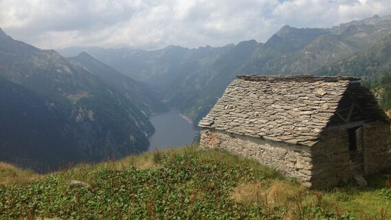
Fusio-Lake Mognola-Fusio
Medium
Vandring
4,7
8,94 km
04:10 h
780 hm
1 280 -
2 075
m
Passo delle Colombe - Passo del Sole
Vandring
5,0
12,4 km
04:25 h
692 hm
1 793 -
2 377
m

Tibet Suspension Bridge Route Riasc
ljus
Vandring
4,7
6,12 km
01:50 h
150 hm
865 -
1 033
m
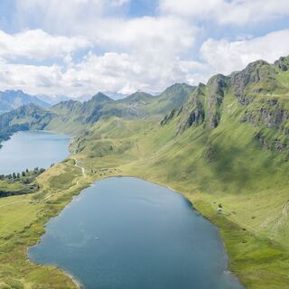
Val Piora lakes route
Medium
Vandring
15,8 km
05:30 h
735 hm
1 782 -
2 184
m
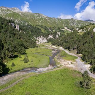
Source of the Brenno
ljus
Vandring
4,7
6 km
01:50 h
142 hm
1 803 -
1 959
m
Lai Blau
Vandring
8 km
03:00 h
550 hm
1 900 -
2 450
m
Discovering the Lakes of Chièra
Medium
Vandring
5,0
8,19 km
05:40 h
740 hm
1 655 -
2 353
m
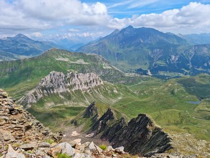
Pizzo Föisch: a view over Val Piora
Vandring
5,0
5,86 km
02:20 h
400 hm
1 802 -
2 185
m

Excursion to the Tremorgio and Morghirolo lakes
tung
Vandring
5,0
24,2 km
09:15 h
1 487 hm
946 -
2 460
m
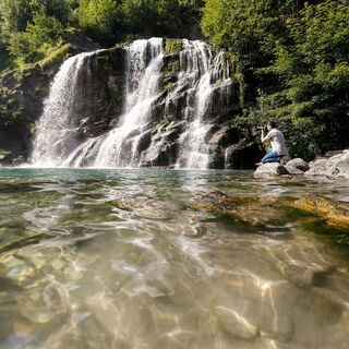
Faido and the Piumogna waterfall
Vandring
3,0
6,94 km
02:05 h
149 hm
672 -
839
m
Brenno riverbanks
Medium
Vandring
5,0
7,23 km
02:15 h
239 hm
1 756 -
1 903
m
Quinto - Capanna Cadagno - Alla Diga
Medium
Vandring
5,0
12,8 km
04:18 h
241 hm
1 800 -
2 127
m
Ladda ner app
Skanna QR-koden nu och ladda ner bergfex -appen

Vandring och spårning


Vandring och spårning

Över 550.000 turförslag, detaljerade kartor och en intuitiv ruttplanerare gör appen till ett måste för alla naturentusiaster.

Missa inte erbjudanden och inspiration inför nästa semester
Prenumerera på nyhetsbrevet
Fel
Ett fel har inträffat. Vänligen försök igen.
Tack för din anmälan
Din e-postadress har lagts till på e-postlistan.
Resor i hela Europa
Österrike
Schweiz
Tyskland
Italien
Slovenien
Frankrike
Nederländerna
Belgien
Polen
Liechtenstein
Tjeckien
Slovakien
Spanien
Kroatien
Bosnien och Hercegovina
Luxemburg
Andorra
Portugal
Island
Storbritannien
Irland
Grekland
Albanien
Nordmakedonien
Malta
Norge
Montenegro
Moldavien
Kosovo
Ungern
San Marino
Rumänien
Estland
Lettland
Belarus
Cypern
Litauen
Serbien
Bulgarien
Monaco
Danmark
Sverige
Finland